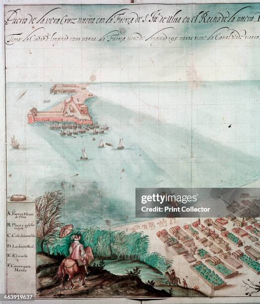
City of Veracruz, Mexico, 17th century. Detail from a map of the city which lies on the Caribbean, on the east coast of Mexico. It was first founded...City of Veracruz, Mexico, 17th century.
map and flag of mexico - veracruz mexico map stock pictures, royalty-free photos & imagesMap and Flag of Mexico
An infographic titled "Mexico forest fires" in Ankara, Turkiye on March 26, 2024. 58 active fires in 15 states, including protected reserves in...Mexico forest fires
shattered map of mexico - veracruz mexico map stock pictures, royalty-free photos & imagesShattered Map of Mexico
old map of showing territory acquired from mexico - veracruz mexico map stock pictures, royalty-free photos & imagesOld map of showing territory acquired from Mexico
old map of general winfield scott 's campaign from veracruz to the city of mexico - veracruz mexico map stock pictures, royalty-free photos & imagesOld map of General Winfield Scott 's campaign from Veracruz to the city of Mexico
panama, panama map, panama, san miguelito, juan diaz, david, arraijan, colon, las cumbres, la chorrera, pedregal, tocumen, santiago de veraguas, parque lefevre, chilibre, cativa, rio abajo, nuevo belen, ancon, alcalde diaz, el chorrillo, changuinola, la c - veracruz mexico map stock illustrationsPANAMA, Panama Map, Panama, San Miguelito, Juan Diaz, David, Arraijan, Colon, Las Cumbres, La Chorrera, Pedregal, Tocumen, Santiago de Veraguas, Parque Lefevre, Chilibre, Cativa, Rio Abajo, Nuevo Belen, Ancon, Alcalde Diaz, El Chorrillo, Changuinola, La C
honduras travel map,tegucigalpa, san pedro sula, choloma, la ceiba, el progreso, ciudad choluteca, comayagua, puerto cortez, la lima, danlí, siguatepeque, juticalpa, villanueva, tocoa, tela, santa rosa de copán, olanchito, san lorenzo, cofradía - veracruz mexico map stock illustrationsHonduras Travel Map,Tegucigalpa, San Pedro Sula, Choloma, La Ceiba, El Progreso, Ciudad Choluteca, Comayagua, Puerto Cortez, La Lima, Danlí, Siguatepeque, Juticalpa, Villanueva, Tocoa, Tela, Santa Rosa de Copán, Olanchito, San Lorenzo, Cofradía
honduras map,tegucigalpa, san pedro sula, choloma, la ceiba, el progreso, ciudad choluteca, comayagua, puerto cortez, la lima, danlí, siguatepeque, juticalpa, villanueva, tocoa, tela, santa rosa de copán, olanchito, san lorenzo, - veracruz mexico map stock illustrationsHonduras Map,Tegucigalpa, San Pedro Sula, Choloma, La Ceiba, El Progreso, Ciudad Choluteca, Comayagua, Puerto Cortez, La Lima, Danlí, Siguatepeque, Juticalpa, Villanueva, Tocoa, Tela, Santa Rosa de Copán, Olanchito, San Lorenzo,
honduras, tegucigalpa, san pedro sula, choloma, la ceiba, el progreso, ciudad choluteca, comayagua, puerto cortez, la lima, danlí, siguatepeque, juticalpa, villanueva, tocoa, tela, santa rosa de copán, olanchito, san lorenzo, - veracruz mexico map stock illustrationsHonduras, Tegucigalpa, San Pedro Sula, Choloma, La Ceiba, El Progreso, Ciudad Choluteca, Comayagua, Puerto Cortez, La Lima, Danlí, Siguatepeque, Juticalpa, Villanueva, Tocoa, Tela, Santa Rosa de Copán, Olanchito, San Lorenzo,
honduras map,tegucigalpa, san pedro sula, choloma, la ceiba, el progreso, ciudad choluteca, comayagua, puerto cortez, la lima, danlí, siguatepeque, juticalpa, villanueva, tocoa, tela, santa rosa de copán, olanchito, san lorenzo, - veracruz mexico map stock illustrationsHonduras Map,Tegucigalpa, San Pedro Sula, Choloma, La Ceiba, El Progreso, Ciudad Choluteca, Comayagua, Puerto Cortez, La Lima, Danlí, Siguatepeque, Juticalpa, Villanueva, Tocoa, Tela, Santa Rosa de Copán, Olanchito, San Lorenzo,
a woman is texting with a smart phone in the city at sunset - veracruz mexico map stock pictures, royalty-free photos & imagesA woman is texting with a smart phone in the city at sunset
honduras travel map,tegucigalpa, san pedro sula, choloma, la ceiba, el progreso, ciudad choluteca, comayagua, puerto cortez, la lima, danlí, siguatepeque, juticalpa, villanueva, tocoa, tela, santa rosa de copán, olanchito, san lorenzo, - veracruz mexico map stock illustrationsHonduras Travel Map,Tegucigalpa, San Pedro Sula, Choloma, La Ceiba, El Progreso, Ciudad Choluteca, Comayagua, Puerto Cortez, La Lima, Danlí, Siguatepeque, Juticalpa, Villanueva, Tocoa, Tela, Santa Rosa de Copán, Olanchito, San Lorenzo,
cartoon map of honduras,tegucigalpa, san pedro sula, choloma, la ceiba, el progreso, ciudad choluteca, comayagua, puerto cortez, la lima, danlí, siguatepeque, juticalpa, villanueva, tocoa, tela, santa rosa de copán, olanchito, san lorenzo, - veracruz mexico map stock illustrationsCartoon Map of Honduras,Tegucigalpa, San Pedro Sula, Choloma, La Ceiba, El Progreso, Ciudad Choluteca, Comayagua, Puerto Cortez, La Lima, Danlí, Siguatepeque, Juticalpa, Villanueva, Tocoa, Tela, Santa Rosa de Copán, Olanchito, San Lorenzo,
This May 25, 2009 photograph shows a likeness of Brussel's most famous statue, Manneken Pis. Created in 1619, Manneken Pis is among Brussels' most...This May 25, 2009 photograph shows a lik
This May 25, 2009 photograph shows a likeness of Brussel's most famous statue, Manneken Pis next to a paper face mask people wore to fend off swine...This May 25, 2009 photograph shows a lik
This May 25, 2009 photograph shows a likeness of Brussel's most famous statue, Manneken Pis. Created in 1619, Manneken Pis is among Brussels' most...This May 25, 2009 photograph shows a lik
Picture taken on April 27, 2009 at his home in La Gloria village of five-year-old Mexican child Edgar Hernandez who contracted, and overcome, the A...(FILES) Picture taken on April 27, 2009
bays and harbors of the americas - veracruz mexico map stock pictures, royalty-free photos & imagesBays and Harbors of the Americas
detail of bays and harbors of the americas from map of north america - veracruz mexico map stock pictures, royalty-free photos & imagesDetail of Bays and Harbors of the Americas from Map of North America
Map of San Juan Evangelista ; a town located in Veracruz; Mexico1580 map of San Juan Evangelista (Cuzcatlan);
Circa 1750, A plan of the city and harbour of La Veracruz - the principal port of New Spain - and the castle of San Juan de Ulua.Map Of Veracruz
Caregiver controls a robot of the project Robot-Era position on the map of a GUI at nursing residence San Lorenzo on December 18, 2015 in Florence,...Robot For Elderly People
Caregiver controls a robot of the project Robot-Era position on the map of a GUI at nursing residence San Lorenzo on December 19, 2015 in Florence,...Robot For Elderly People
historical map of the country of mexico, published in 1885. estados unidos mexicanos, veracruz - veracruz mexico map stock illustrationsHistorical Map of the Country of Mexico, Published in 1885. Estados Unidos Mexicanos, Veracruz
a woman is texting with a smart phone in the city at sunset - veracruz mexico map stock pictures, royalty-free photos & imagesA woman is texting with a smart phone in the city at sunset
old map of general winfield scott 's campaign from veracruz to the city of mexico - veracruz mexico map stock pictures, royalty-free photos & imagesOld map of General Winfield Scott 's campaign from Veracruz to the city of Mexico
hurricane nate 2011 track gulf of mexico infographic - veracruz mexico map stock illustrationsHurricane Nate 2011 Track Gulf Of Mexico Infographic
hurricane ingrid 2013 track gulf of mexico infographic - veracruz mexico map stock illustrationsHurricane Ingrid 2013 Track Gulf Of Mexico Infographic
Guatemalan immigrants Raymundo Cruz and fourteen-year-old Oswaldo Ramirez - in their third and second attempts respectively to reach the US - remain...MEXICO-IMMIGRATION-JOURNEY
This May 25, 2009 photograph shows a likeness of Brussel's most famous statue, Manneken Pis. Created in 1619, Manneken Pis is among Brussels' most...US-HEALTH-FLU-MEXICO-OFFBEAT
This May 25, 2009 photograph shows a likeness of Brussel's most famous statue, Manneken Pis next to a paper face mask people wore to fend off swine...US-HEALTH-FLU-MEXICO-OFFBEAT
This May 25, 2009 photograph shows a likeness of Brussel's most famous statue, Manneken Pis. Created in 1619, Manneken Pis is among Brussels' most...US-HEALTH-FLU-MEXICO-OFFBEAT
panama, panama map, panama, san miguelito, juan diaz, david, arraijan, colon, las cumbres, la chorrera, pedregal, tocumen, santiago de veraguas, parque lefevre, chilibre, cativa, rio abajo, nuevo belen, ancon, alcalde diaz, el chorrillo, changuinola - veracruz mexico map stock illustrationsPANAMA, Panama Map, Panama, San Miguelito, Juan Diaz, David, Arraijan, Colon, Las Cumbres, La Chorrera, Pedregal, Tocumen, Santiago de Veraguas, Parque Lefevre, Chilibre, Cativa, Rio Abajo, Nuevo Belen, Ancon, Alcalde Diaz, El Chorrillo, Changuinola
honduras, tegucigalpa, san pedro sula, choloma, la ceiba, el progreso, ciudad choluteca, comayagua, puerto cortez, la lima, danlí, siguatepeque, juticalpa, villanueva, tocoa, tela, santa rosa de copán, olanchito, san lorenzo, - veracruz mexico map stock illustrationsHonduras, Tegucigalpa, San Pedro Sula, Choloma, La Ceiba, El Progreso, Ciudad Choluteca, Comayagua, Puerto Cortez, La Lima, Danlí, Siguatepeque, Juticalpa, Villanueva, Tocoa, Tela, Santa Rosa de Copán, Olanchito, San Lorenzo,
honduras travel map,tegucigalpa, san pedro sula, choloma, la ceiba, el progreso, ciudad choluteca, comayagua, puerto cortez, la lima, danlí, siguatepeque, juticalpa, villanueva, tocoa, tela, santa rosa de copán, olanchito, san lorenzo, - veracruz mexico map stock illustrationsHonduras Travel Map,Tegucigalpa, San Pedro Sula, Choloma, La Ceiba, El Progreso, Ciudad Choluteca, Comayagua, Puerto Cortez, La Lima, Danlí, Siguatepeque, Juticalpa, Villanueva, Tocoa, Tela, Santa Rosa de Copán, Olanchito, San Lorenzo,
panama cartoon map, panama, san miguelito, juan diaz, david, arraijan, colon, las cumbres, la chorrera, pedregal, tocumen, santiago de veraguas, parque lefevre, chilibre, cativa, rio abajo, nuevo belen, ancon, alcalde diaz, el chorrillo, changuinola - veracruz mexico map stock illustrationsPanama Cartoon Map, Panama, San Miguelito, Juan Diaz, David, Arraijan, Colon, Las Cumbres, La Chorrera, Pedregal, Tocumen, Santiago de Veraguas, Parque Lefevre, Chilibre, Cativa, Rio Abajo, Nuevo Belen, Ancon, Alcalde Diaz, El Chorrillo, Changuinola
panama map, panama, san miguelito, juan diaz, david, arraijan, colon, las cumbres, la chorrera, pedregal, tocumen, santiago de veraguas, parque lefevre, chilibre, cativa, rio abajo, nuevo belen, ancon, alcalde diaz, el chorrillo, changuinola, la cabima, l - veracruz mexico map stock illustrationsPanama Map, Panama, San Miguelito, Juan Diaz, David, Arraijan, Colon, Las Cumbres, La Chorrera, Pedregal, Tocumen, Santiago de Veraguas, Parque Lefevre, Chilibre, Cativa, Rio Abajo, Nuevo Belen, Ancon, Alcalde Diaz, El Chorrillo, Changuinola, La Cabima, L
Guatemalan immigrants Raymundo Cruz and fourteen-year-old Oswaldo Ramirez - in their third and second attempts respectively to reach the US - remain...TO GO WITH AFP STORY BY OSCAR BATRES Gua